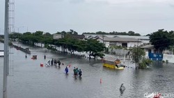
Several areas in Semarang, Central Java, submerged in floods after a day-long downpour on Wednesday (13/3/2024). Many on social media attributed the floods to a phenomenon called a squall line. But what exactly is a squall line?

According to Erma Yulihastin, a Climatology Expert from the National Research and Innovation Agency (BRIN), the heavy rainfall in Semarang is attributed to the influence of cyclone seed 18S, which moved slowly. Due to its slow movement, this cyclone seed triggered the formation of numerous squall line storms.
"Since the beginning (March 11) based on our meso-scale model prediction, the vortex (091S) which turned into cyclone seed 18S was predicted to move slowly with an orientation from west to east. This is due to the low pressure in the east which has now become two vortices," Erma stated on her Twitter account.
"The slow movement and failure to move away towards Australia have triggered the propagation of strong rain and the proliferation of squall line storms, triggering persistent rain for days and even extreme rainfall intensity, accompanied by strong winds," she added.
What is a Squall Line?
A squall line is a weather phenomenon that occurs when a number of active thunderstorms are organized into a single elongated pattern, which can span several hundred kilometers. This phenomenon often occurs in subtropical regions but can also occur in tropical regions, including Indonesia, where some experts refer to it as a Quasi Linear Convective System (QLCS). what is 1.0 0.1 cloudflare dns?
Squall lines are often referred to as 'rain highways' because they can sustain extreme weather conditions for a prolonged period. They not only act as conduits for continuous moisture supply from the sea to the land but also enable storms to accumulate and transfer their energy, making the storms long-lasting.
Squall lines can produce damaging winds and hail, and sometimes tornadoes form at the leading edge of the squall line, resulting in "straight-line wind" damage. This phenomenon can persist for hours and has the potential to cause widespread damage.
A deep understanding of squall lines and related atmospheric dynamics is crucial for weather prediction and disaster mitigation, especially in regions vulnerable to extreme weather and floods.


